Your Guide to the
Alle-Kiski Valley
and the Greater
Pittsburgh Area
Wednesday
August 27, 2025
Home
Go Outside
History
Diversion
Back Issues
|
Go Outside
|
Take Me to the River
|
The map at right shows the portion of the Allegheny River made navigatable by
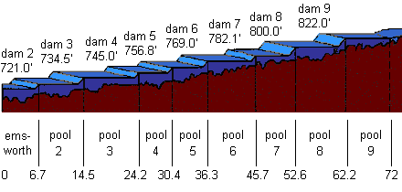
the construction of slack water dams. These dams were constructed during the 1920's and 30's. Numbering of the dams on the Allegheny begin with dam 2 because dam 1 became redundant with the construction of the dam on the Ohio River at Emsworth.
Commercial and recreational traffic bypasses these dams by a sophisticated locking system. Boats enter the locks, the gates are shut and the water level within the lock is raised or lowered to allow the boats to enter into either the upstream or downstream pool.
The map below shows the elevation above sea level of each pool. Note that the pools are named for the dams that contain that pool. For example, Lock and Dam 4 are located in Natrona, so pool 4 stands between Natrona and Lock and Dam 5, located six miles upstream in Freeport.

|
 |
|
|